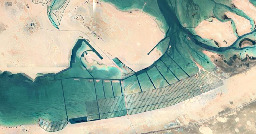
What are these elongated rectangles in the water area?


Found on a google maps trip to Al Jirab, Along the E11 24°05'14.0"N 53°55'27.0"E
I found this while looking for interesting places to share on the Top View community here on Lemmy

After some more research, the most likely candidates:
mangrove nurseries, salt harvesting, algae farm, coral nurseries.
But nothing yet is confirmed!


 -----
-----
You are viewing a single comment
Salt harvesting?
Edit: apparently mangrove plantations.
It could be yeah! I Just can't find any info on it online
Wouldn't they have to be inverted? Raised walls to partition and ponds in between