What are these elongated rectangles in the water area?

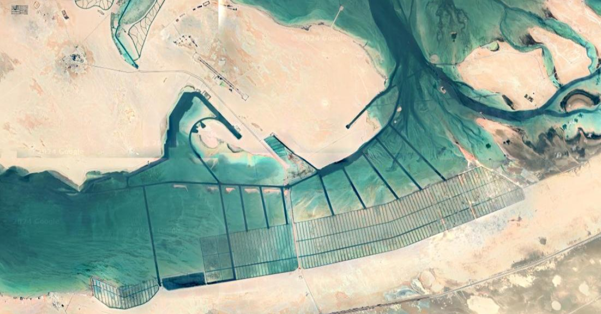
Found on a google maps trip to Al Jirab, Along the E11 24°05'14.0"N 53°55'27.0"E
I found this while looking for interesting places to share on the Top View community here on Lemmy

After some more research, the most likely candidates:
mangrove nurseries, salt harvesting, algae farm, coral nurseries.
But nothing yet is confirmed!


 -----
-----
Unrelated, but I love that you discovered this image and worked so hard to figure out the answer to your question. I had also never heard of the Top View community, and it’s so interesting - subscribed! Thanks, OP :)
I also subscribed!
Salt harvesting?
Edit: apparently mangrove plantations.
It could be yeah! I Just can't find any info on it online
Wouldn't they have to be inverted? Raised walls to partition and ponds in between
I think I may have found the answer? After researching a little bit it looks like Abu al Abyad, the island above the elongated rectangles is actually an international military testing facility. This article , and a couple similar to it alluded that the area is for testing naval equipment and amphibious landings.
There are similar man made pools of salt water in desert condition that the US utilizes for radar testing at the China Lake research facility in California.
Could also be algae farming, but it looks more like salterns.
Maybe the name (arabic: الخضيرة, English Al Khidayrah) helps.
See https://www.openstreetmap.org/node/9971473918#map=12/24.1032/53.9868
Thanks!
I mostly just found other posts (on reddit) about the same place, but no definite answer. Most likely it sounds like a mangrove plantation though
They're water farms, they just happen to be rectangular in shape thanks to the Seigneurial system
But this is salt water. How can they grow crops in that?
Flood the plane, let the water evaporate, and you've got yourself some salt buddy
Now if only we could do the same with pepper, we'd be set
Ah ... didn't know that seasalt evaporation ponds are called water farms!
I assumed you meant crop farming in water
But yeah salt harvesting is one of the possibilities I originally posted in the description of the post. Others have commented that it does not seem likely when looking at the closeups.
My bet is on mangrove nursery
Water streets.