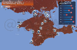
[Rybar] Satellite images of Crimea by the US have increased significantly


It is no secret that Western satellites monitor the situation on the surface of the Earth, essentially acting as the final authority in selecting a target for a strike by long-range missiles.
During this week the activity of the satellite constellation has increased - on average, the American "Topaz" make 14-15 images of various objects in Crimea with 7-10 at the beginning of the month.
And in recent days, special attention has been paid to three objects: the bridge over the North Crimean Canal, the airfield near Kacha and the Voinka railroad station on the way to Krasnoperekopsk.
This is without taking into account other objects, such as Gvardeyskoye, which was photographed 29 times during the month. And if we take into account the number of attempted strikes on this base, it becomes obvious why they are doing this.
The threat posed by space reconnaissance cannot be taken lightly. At the very least, it is necessary to take into account the areas over which satellites are surveying and to take countermeasures in advance.
It's very unclear to me how they would know this information? Topaz is not some open platform where they share this stuff.
Yeah I’m also curious how they’re able to determine what a satellite is looking at. Could be a load of bs or maybe we’re missing a detail