Google Maps for Wear OS adds public transit directions


9to5google.com
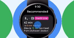
Google today announced a handful of wearable and navigation updates, starting with public transit directions in Google Maps for Wear OS.
Google today announced a handful of wearable and navigation updates, starting with public transit directions in Google Maps for Wear OS.
wtf i assumed it was present since version 0.9 beta.
What's the point of having a smartwatch sized smartphone on the wrist if it can't even give you directions?
I wish they didn't fuck the public transit directions in general, if I want to use them I used to be able to say "i just want to use the train"
Now it's impossible because it automatically decides I wanted to use a bus to connect to each train stop, not allowing for the correct calculations to make a route based on train and foot traffic only. It's not like I can just ignore the bus options because suddenly that means an hour walk. I'm back to the dark ages of printing out fucking directions
Fucking finally.
it's such an easy thing to code. They take ages for basic features.
What may seem easy to an outstanding person is most definitely not easy in reality. There is so much more complexity involved in this, and not even speaking of the whole corporate nightmare new features have to go through.
okay. if they had never done it maybe. but its in Google maps already. So they already have all the data available. Making the code to show transit, with having access to their internal API's is probably very easy.
Just look up a local bus provider API. Very easy to just make a request. Google probably has their own API already that bundles all transits from over the world.
I do wish they had live tracking of more bus opators