Are you made from sugar! That looks totally doable! Amphibious forging hurrah!
road bike :(
I don't think Google has a road/mountain bike toggle for navigation does it? ☹️
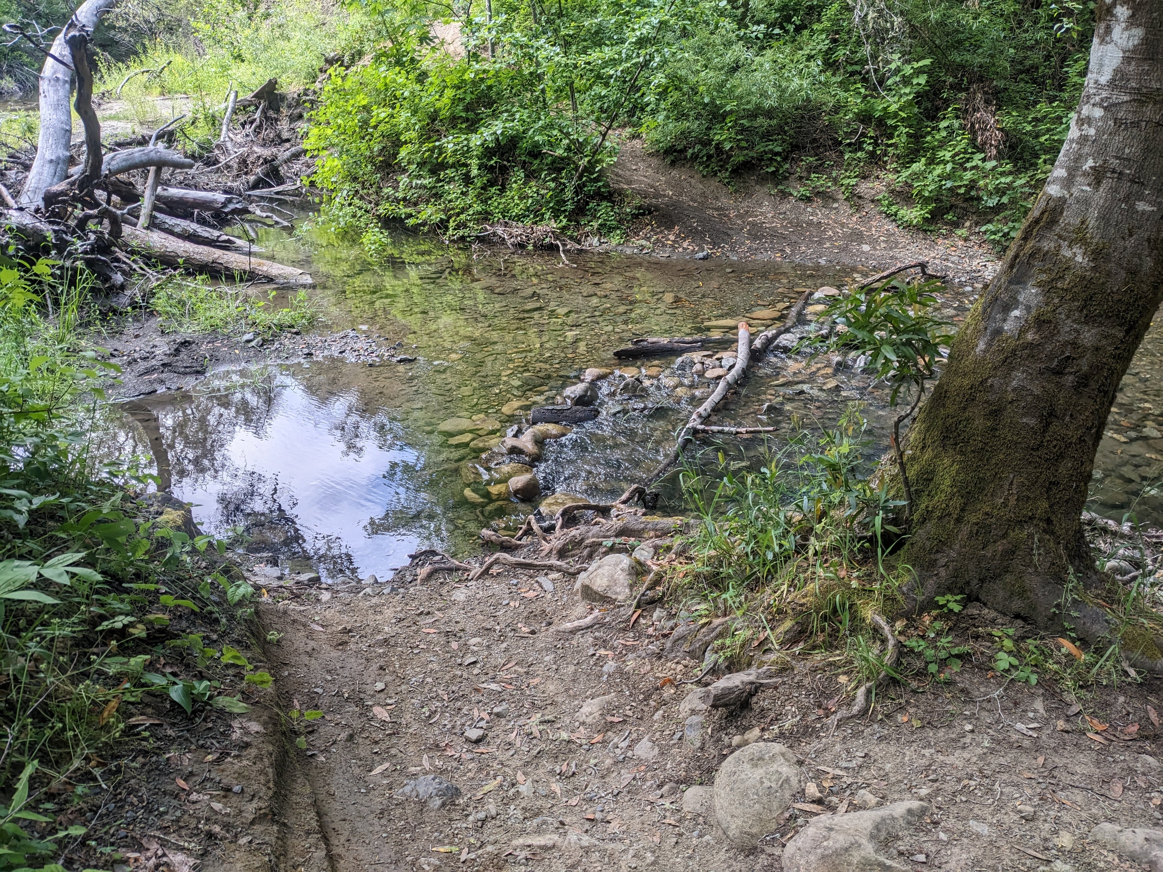
I mean maybe I'm just wired differently but this looks pretty fine for any bike? Water seems to be only about 20cm deep and the ground below is relatively even stones. And on the other side, the path goes up fine.
That looks fun, much better than the usual google bike suggestions of join this main road that has a 70mph speed limit
I would ride that.
Looks to be shallow enough to (at least mostly) avoid getting wet feet and the bottom looks firm, I'd give it a go without worrying too much. Could be awkward with the skinny tyres of a road bike but I'm assuming from the lead in and out being dirt that this is a track where one has at least brought a gravel bike.
That's why OpenStreetMap and a user friendly client app like Komoot is usually the better option for planning offroad activities.
Even if this state isn't mapped yet, you'd just add the surface state and the blockage for the next person.
Do it!!!
I had to. It is few weeks old foto - behind me is steep gravel downhill and you see this streem in the last moment so I had to slam my brakes. One side had pretty big stones so if I didn't check it I would end up in it.
How bad is it when you end up cycling into a pit like this, potentially at some speed? Has the water made the soil soft in the road leading the front wheel potentially getting stuck and throwing you off, or will you most likely cycle through with a significant splash and be on your way?
I guess a huge part of it might be the problem of not being able to see so well what's under the water, in case the road has been damaged?
You are right - you don't see what's under water. These are streams (op's and mine photo) so there is usually hard gravel so no problem with 30mm+ tires.
In my case there were bigger stones so if you hit them in best case you fell off bike, in worst case you fell off and damage wheels.
Sometimes it is best to get off and push your bike.
Get good
If it's just a one time road block and you don't want to drive through the water, you could have still get out of your shoes and carry the bike over there. On the left side you could probably even hop from trunk to trunk.
The path looks nice and thanks to the little creek, it's probably less crowded. ;)
Half the fun of trail riding is handling dynamic stuff like this.
A downed tree and a puddle. Depending on how strong you are, you might even be able to move that tree and solve the problem yourself.
Puddle looks pretty new, so the ground probably isn’t horribly soft underneath it.
Google Maps is whack now. For some reason, they decided to get rid of the camera following directly behind your GPS marker.
Tip: you probably had it set on the Red Bull Extreme Sports BMX setting.
I see no 50ft drops here.
I see no 50ft drops here yet
Just walk your bike across it, geez.
I wonder how it looked like when it was actually marked as a bikeable trail. I can imagine the amount of water changes throughout the seasons. Or years. Or aeons.


Are you made from sugar! That looks totally doable! Amphibious forging hurrah!
road bike :(
I don't think Google has a road/mountain bike toggle for navigation does it? ☹️
I mean maybe I'm just wired differently but this looks pretty fine for any bike? Water seems to be only about 20cm deep and the ground below is relatively even stones. And on the other side, the path goes up fine.
That just makes it more fun.
Skill issue
git gud
Anything is bikeable if you pedal hard enough!
That looks fun, much better than the usual google bike suggestions of join this main road that has a 70mph speed limit
I would ride that.
Looks to be shallow enough to (at least mostly) avoid getting wet feet and the bottom looks firm, I'd give it a go without worrying too much. Could be awkward with the skinny tyres of a road bike but I'm assuming from the lead in and out being dirt that this is a track where one has at least brought a gravel bike.
That's why OpenStreetMap and a user friendly client app like Komoot is usually the better option for planning offroad activities.
Even if this state isn't mapped yet, you'd just add the surface state and the blockage for the next person.
Do it!!!
I had to. It is few weeks old foto - behind me is steep gravel downhill and you see this streem in the last moment so I had to slam my brakes. One side had pretty big stones so if I didn't check it I would end up in it.
How bad is it when you end up cycling into a pit like this, potentially at some speed? Has the water made the soil soft in the road leading the front wheel potentially getting stuck and throwing you off, or will you most likely cycle through with a significant splash and be on your way?
I guess a huge part of it might be the problem of not being able to see so well what's under the water, in case the road has been damaged?
You are right - you don't see what's under water. These are streams (op's and mine photo) so there is usually hard gravel so no problem with 30mm+ tires.
In my case there were bigger stones so if you hit them in best case you fell off bike, in worst case you fell off and damage wheels.
Sometimes it is best to get off and push your bike.
Get good
If it's just a one time road block and you don't want to drive through the water, you could have still get out of your shoes and carry the bike over there. On the left side you could probably even hop from trunk to trunk.
The path looks nice and thanks to the little creek, it's probably less crowded. ;)
Half the fun of trail riding is handling dynamic stuff like this.
A downed tree and a puddle. Depending on how strong you are, you might even be able to move that tree and solve the problem yourself.
Puddle looks pretty new, so the ground probably isn’t horribly soft underneath it.
Google Maps is whack now. For some reason, they decided to get rid of the camera following directly behind your GPS marker.
Tip: you probably had it set on the Red Bull Extreme Sports BMX setting.
I see no 50ft drops here.
I see no 50ft drops here yet
Just walk your bike across it, geez.
I wonder how it looked like when it was actually marked as a bikeable trail. I can imagine the amount of water changes throughout the seasons. Or years. Or aeons.